| Country: | United States | ||
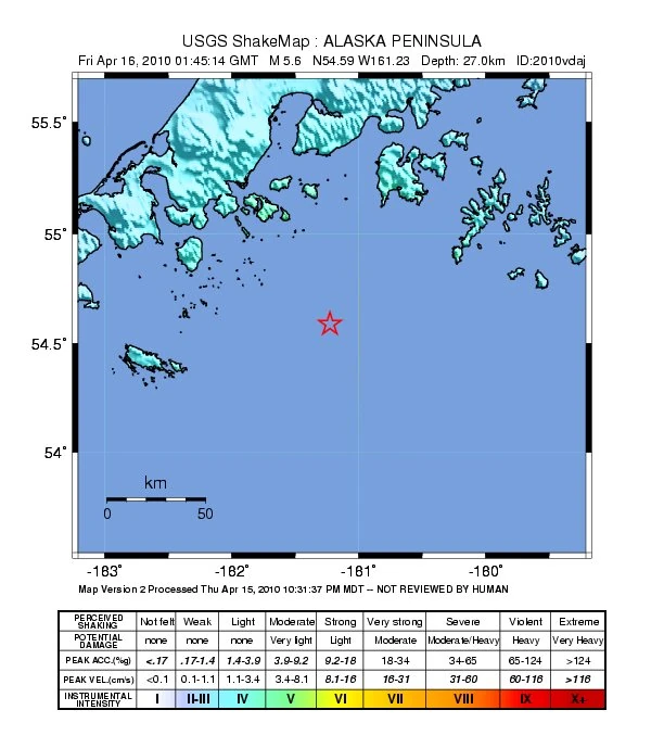
| Date (local): | April 15, 2010, 17:45:14 | ||
| Date (UTC): | Apr. 16, 01:45:14 | ||
| Magnitude: | 5.7 Mw | ||
| Max. Intensity:[1] | VII | ||
| Population exposure:[1] |
| ||
| Depth: | 27 km | ||
| Epicenter coordinates: | 54.588°N, 161.228°E | ||
| Epicenter location: | 88 km SE of King Cove AK | ||
| Flinn-Engdahl region: | 012 — Alaska Peninsula, United States | ||
| Type: | subduction zone | ||
| Countries/ regions affected: |
Alaska (USA) | ||
| Tectonic plates: | Pacific Plate, North American Plate |
Earthquakes in 2010, Alaska – Aleutian Islands Arc (M5.5 and above)
16 Jan (5.5) • 9 Mar (5.7) • 15 Apr (5.7) • 30 Apr (6.4) • 30 Apr (6.0) • 3 May (5.5)
Earthquakes in the FE region 012 (Alaska Peninsula, United States) in 2001–2010
23 Jun 2001 (5.5) • 20 Dec 2001 (5.6) • 26 Nov 2002 (5.6) • 27 Feb 2003 (5.5) • 27 Jan 2004 (5.6) • 2 Oct 2007 (6.3) • 2 Oct 2007 (5.6) • 26 Oct 2007 (5.5) • 1 May 2009 (5.6) • 15 Apr 2010 (5.7)