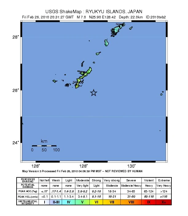
| Country: | Japan |
| Date (local): | February 27, 2010, 05:31:27 |
| Date (UTC): | Feb. 26, 20:31:27 |
| Magnitude: | 7.0 Mw |
| Max. Intensity:[1] | X |
| Depth: | 22 km |
| Epicenter coordinates: | 25.902°N, 128.417°E |
| Epicenter location: | 80 km ESE of Naha, Okinawa |
| Flinn-Engdahl region: | 238 — Ryukyu Islands, Japan |
| Type: | subduction zone |
| Countries/ regions affected: |
Japan |
| Tectonic plates: | Okinawa Plate, Philippine Sea Plate |
- ↑ This information is based on an automatic estimation by the PAGER system and is sometimes not updated when the magnitude of the earthquake is updated. It might therefore be not correct.
Earthquakes in 2010, Southwestern Japan and Ryukyu Islands (M5.5 and above)
Earthquakes in the FE region 238 (Ryukyu Islands, Japan) in 2001–2010
5 Mar 2001 (5.5) • 18 Aug 2001 (5.9) • 31 Oct 2001 (5.5) • 9 Dec 2001 (6.2) • 10 Jul 2003 (5.5) • 28 Sep 2003 (5.7) • 22 Jul 2004 (6.1) • 25 Jul 2004 (5.5) • 29 Dec 2004 (5.7) • 4 Dec 2005 (5.9) • 13 Aug 2006 (5.5) • 1 Sep 2006 (5.5) • 18 Nov 2006 (6.2) • 11 Dec 2006 (5.7) • 21 Apr 2007 (5.7) • 8 Jul 2008 (6.0) • 21 Feb 2009 (5.5) • 29 Sep 2009 (5.8) • 30 Oct 2009 (6.8) • 15 Jan 2010 (5.7) • 27 Feb 2010 (7.0)